
Showing posts with label A to Z April Challenge 2016. Show all posts
Showing posts with label A to Z April Challenge 2016. Show all posts
Wednesday, April 24, 2019
Monday, May 9, 2016
A to Z April Challenge - Reflections

Not long after I started my blog, The Past Whispers, about the genealogy of my family, I stumbled upon a post on Facebook that mentioned the A to Z Challenge, I was immediately interested. After reading the rules I joined and decided I would write about the place names in the province of Quebec, my home. What fun!
In being a part of the challenge I researched, formulated a post a day, traveled to other blogs to read posts I would have otherwise never had the chance to see, and I learned a great deal about the country in which I was born.
The people who set up this challenge did a marvelous job, kudos to you! Would I ever do another blogging challenge, yes, in a heartbeat!
See everyone next time!
Saturday, April 30, 2016
Z is for Zamboni
If necessity is the mother of invention, Frank J.
Zamboni might be considered its father. This tireless
inventor/entrepreneur never came across an obstacle he couldn’t tinker
his way around.
Frank J. Zamboni was born on January 16, 1901 in Eureka, Utah. Frank’s parents moved their family (with one year old Frank in tow) from Eureka to a farm in Idaho, where Frank developed his mechanical skills.
For more information about the Zamboni family history, see “The Man Behind the Machine”.
In 1920, Frank moved to Southern California with his brother Lawrence to join their older brother George in his auto repair business. After a short time tinkering on cars, the two younger Zambonis decided to open an electrical service business catering to the local dairy industry. The brothers installed many refrigerator units dairies used to keep their milk cool.
When the demand for cooling expanded into the produce industry, the brothers expanded their business vision, as well: they built a plant that made the block ice wholesalers used to pack their product that was transported by rail across the country. But as refrigeration technology improved, demand for block ice began to shrink, and Frank and Lawrence started looking for other ways to capitalize on their expertise with ice.
That opportunity came in the sport of ice skating. Popularity of the sport was growing, but there were few rinks in Southern California, so in 1939 Frank, Lawrence, and a cousin built Iceland Skating Rink in Paramount. The rink still operates today just blocks from the Zamboni factory. In fact, it’s not unusual to see Zamboni ice resurfacers driving down the neighborhood streets on their way to be tested at Iceland.
Since Frank Zamboni’s introduction of the world’s first self-propelled ice resurfacing machine in 1949, his business naturally began to grow as more people became aware of his innovative product. In the 1950’s, Frank J. Zamboni & Co., Inc. began to advertise in a variety of ice industry and arena management publications. These are a few of those early advertisements.

Friday, April 29, 2016
Y is for the Yamaska River
 | ||
| Yamaska River at Saint - Hyacinthe - Gregory Lussier |
Sourcing water within the Eastern Townships, it ends its journey in Lake Saint-Pierre where it is a tributary to the Saint Lawrence River; altogether it is 177 km (110 mi) long. Crossing nearly twenty municipalities in its course, it is intrinsically linked to life around it as it is a primary source of fresh water where it passes; due to human use and adaptation, the river and its banks have become heavily altered over time, beginning around the time the first European settlers arrived to modern days.
The name Yamaska appeared in the 17th century, beforehand it was named "Rivière de Gennes" (French for River of Gennes) by Samuel de Champlain in 1609. When the lands known as seigneurie de Yamaska were granted to Michel Leneuf de La Vallière, the river's name was instead "rivière des Savanes".
The word "Yamaska" could be sourced to Abenakis meaning "there are rushes off the coast" or "there is much hay", from yam or iyamitaw, respectively meaning off shore and much, and askaw, meaning hay or rushes.
This Amerindian name references baie de Lavalilière (Lavallière Bay), at the river's mouth where vegetation grows abundantly in a marsh. The name could also be from Algonquian hia muskeg, it means "river of the savannas" or "river with muddy waters".
Because of the nebulous Amerindian origin, this naming has been deformed (often in the form of Maska or Masca, after which the inhabitants of Saint-Hyacinthe are named). It was officially named Rivière Yamaska 5 December 1968.
Thursday, April 28, 2016
X is for Xena, Saskatchewan
Xena, Saskatchewan was a village in Saskatchewan. The last building was demolished in the 1970s. It is now an unincorporated area in the rural municipality of Morris No. 312, in the Canadian province of Saskatchewan. Xena is located on Highway 2 in central Saskatchewan.
Xena was part of the Grand Trunk Pacific Railway later named the Canadian National Railway alphabet railway naming system appearing between Watrous and Young.
Saskatchewan Gen Web - One Room School Project
Saskatchewan is 34 hr.s (3,224 km) from Saint - Hyacinthe and 36 hrs. (3,445 km) from Quebec City.
Wednesday, April 27, 2016
W is for Wolfe's Cove
Formerly the Anse au Foulon.
A mile and a half above the city of Quebec.
In 1759 the French had a post there, commanded by de Vergor. Early on the morning of September 13th Wolfe landed with his army at the foot of the cliffs; a small party of volunteers climbed the steep path and surprised and overpowered de Vergor's handful of men; the army followed - "In the gray of the morning the long file of red-coated soldiers moved quickly upward, and formed in order on the plateau above;" the first step had been successfully taken in the movement that led to the Battle of the Plains and the cession of Canada to Great Britain.
My Irish great-grandparents lived in Wolfe's Cove for a time, he being a stevedore working on the docks weather permitting as no ships could break through the ice of the St. Lawrence River in winter.

Three hundred and thirty feet below Quebec City runs Wolfe's Cove Tunnel.
The 1800-foot-long tunnel was built by the Canadian Pacific Railways in 1930. It passes beneath Belvedere Avenue and the Plains of Abraham and was built primarily to serve as the pickup for the trans-Atlantic Empress ship. With ship traffic transferred to Montreal by the 1950s, the rail switched to freight.
While the tunnel is easily accessible by foot, one should be very careful if they choose to enter the tunnel (we do not recommend it) as the Wolfe's Cove Tunnel continues to have trains running through it, approximately 3 or 4 per week, rail transportation services only.
The South portal is just east of Gilmour's Hill, hidden under Champlain Boulevard. The North portal is accessible by West Charest Boulevard, between the streets Vincent Massey and De Verdun.
Wolfe's Cove is 195 km ( 1 hr. 55 min.) from Saint - Hyacinthe, QC.

In 1759 the French had a post there, commanded by de Vergor. Early on the morning of September 13th Wolfe landed with his army at the foot of the cliffs; a small party of volunteers climbed the steep path and surprised and overpowered de Vergor's handful of men; the army followed - "In the gray of the morning the long file of red-coated soldiers moved quickly upward, and formed in order on the plateau above;" the first step had been successfully taken in the movement that led to the Battle of the Plains and the cession of Canada to Great Britain.
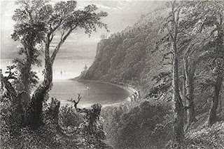
 |
| Wolfe's Cove - 1860 |
My Irish great-grandparents lived in Wolfe's Cove for a time, he being a stevedore working on the docks weather permitting as no ships could break through the ice of the St. Lawrence River in winter.

Three hundred and thirty feet below Quebec City runs Wolfe's Cove Tunnel.
The 1800-foot-long tunnel was built by the Canadian Pacific Railways in 1930. It passes beneath Belvedere Avenue and the Plains of Abraham and was built primarily to serve as the pickup for the trans-Atlantic Empress ship. With ship traffic transferred to Montreal by the 1950s, the rail switched to freight.
While the tunnel is easily accessible by foot, one should be very careful if they choose to enter the tunnel (we do not recommend it) as the Wolfe's Cove Tunnel continues to have trains running through it, approximately 3 or 4 per week, rail transportation services only.
The South portal is just east of Gilmour's Hill, hidden under Champlain Boulevard. The North portal is accessible by West Charest Boulevard, between the streets Vincent Massey and De Verdun.
Wolfe's Cove is 195 km ( 1 hr. 55 min.) from Saint - Hyacinthe, QC.
 | ||||||||||||||||||||||||||||||||||||||||||||||||||||||||||||||||||||||||||||||||||||||||||||||||||||||||||||||||||||||||||||||||||||||||||||||||||||||||||||||||||||||||||||||||||||||||||||||||||||||||||||||||||||||||||||||||||||||||||
| Wolfe's Cove - 1860 |
Tuesday, April 26, 2016
V is for The Battle of Vimy Ridge
Remembering the Fallen: Canadian National Vimy Memorial

The Canadian National Vimy Memorial at Vimy Ridge on the 1914-1918 Artois battlefields, northern France.
Designed by Canadian sculptor and architect Walter Seymour Allward,
the Canadian National
Vimy Memorial stands on Hill 145, overlooking the Canadian battlefield
of 1917, at one of the points of the fiercest fighting. It took 11 years
and $1.5 million to build and was unveiled on July 26, 1936 by King
Edward VIII, in the presence of President Albert Lebrun of France and
50,000 or more Canadian and French Veterans and their families. In his
address, the King noted, "It is a memorial to no man, but a memorial for
a nation."
At the base of the Memorial, in English and in French, are these words:
To the valour of their countrymen in the Great War
and in memory of their sixty thousand dead this monument is raised by the people of Canada.
In fact, more than 66,000 Canadians died in action, or of their wounds after the war—more than one in ten of those who had worn uniforms. Among the dead are many who have no known grave. Inscribed on the ramparts of the Memorial are the names of 11,285 Canadian soldiers who were posted "missing, presumed dead" in France. Another 6,994 names of missing Canadians are carved on the Menin Gate at Ypres, Belgium.
CWGC Cemetery Record Search: Vimy Memorial
In 1922, use of the land for the battlefield park which contains the Canadian National Vimy Memorial was granted for all time by the French nation to the people of Canada. The Memorial rests on a bed of 11,000 tonnes of concrete and masonry, reinforced by hundreds of tonnes of steel. Many live bombs and shells were unearthed during the excavation. Today's visitors will find the now grassy grounds still pock-marked with the depressions of mine-craters, shell-holes and mounds from the massive artillery bombardment which the Canadians used to take Vimy Ridge.
The Memorial's two towering pylons and a score of symbolic, twice-life-sized sculptured figures contain almost 6,000 tonnes of limestone, brought to the site from an ancient quarry in Yugoslavia. The figures were carved where they now stand from huge limestone blocks over a 10-year-span.
The troops of the Canadian Corps of the First World War were superbly capable citizen-soldiers, tested in the cruel crucible of war. But their dreams were of peace. The people of Canada still respect those dreams and that sacrifice. Canadians strive to ensure that the dreams are realized and the sacrifice honoured, now and in the years to come. Then the valiant soldiers of Vimy may continue to rest in peace.
Monday, April 25, 2016
U is for Uxbridge, Ontario
I had to move out of the province of Quebec to find a city/town that started with a U for the A to Z Challenge, I found myself in south-central Ontario in the town of Uxbridge.
It was named for Uxbridge, England, a name which was originally derived from "Wixan's Bridge". The Wixan were a 7th-century Saxon tribe from Lincolnshire who also began to settle in what became Middlesex.
The first settlers in the area were Quakers who started arriving in 1806 from the Catawissa area of Pennsylvania. The community's oldest building, the Uxbridge Friends Meeting House, was built in 1820 and overlooks the town from Quaker Hill, a kilometre to the west.
The township was incorporated as a municipality in 1850 and became part of the newly formed Ontario County two years later.
The first passenger carrying narrow gauge railway in North America, the Toronto and Nipissing Railway arrived in Uxbridge in June 1871, and for over a decade Uxbridge was the headquarters of the railway. In 1872, the Village of Uxbridge was separated from the Township and incorporated as a separate entity.
In 2009 Uxbridge Township received federal designation by Industry Canada as The Trail Capital of Canada, resulting from the over 220 kilometers of managed trails on over 8,000 acres (32 km2) of protected greenspace within its borders. Uxbridge trails run through and alongside historic villages, mixed forests, meadows, ponds, streams, and wetlands. A number of major trail systems run through the Township, including the Oak Ridges Trail and the Trans-Canada Trail.
Being a bit of a film buff I was surprised and pleased to see how many films used Uxbridge at least partly, as their location. Films such as:
The House Without A Christmas Tree - 1972
The Littlest Hobo - 1980's (dog story)
Road To Avonlea
Once Upon A Hamster - 1995
Christmas In My Hometown - 1996
The Long Kiss Goodnight - 1996
Jerry and Tom - 1998
A Map of the World - 1999
Driven - 2001
Serendipity - 2001
Prancer Returns - 2001
A History of Violence - 2005
Lars and the Real Girl - 2007
Grey Gardens - 2009
The Township of Uxbridge
It was named for Uxbridge, England, a name which was originally derived from "Wixan's Bridge". The Wixan were a 7th-century Saxon tribe from Lincolnshire who also began to settle in what became Middlesex.
The first settlers in the area were Quakers who started arriving in 1806 from the Catawissa area of Pennsylvania. The community's oldest building, the Uxbridge Friends Meeting House, was built in 1820 and overlooks the town from Quaker Hill, a kilometre to the west.
The township was incorporated as a municipality in 1850 and became part of the newly formed Ontario County two years later.
The first passenger carrying narrow gauge railway in North America, the Toronto and Nipissing Railway arrived in Uxbridge in June 1871, and for over a decade Uxbridge was the headquarters of the railway. In 1872, the Village of Uxbridge was separated from the Township and incorporated as a separate entity.
In 2009 Uxbridge Township received federal designation by Industry Canada as The Trail Capital of Canada, resulting from the over 220 kilometers of managed trails on over 8,000 acres (32 km2) of protected greenspace within its borders. Uxbridge trails run through and alongside historic villages, mixed forests, meadows, ponds, streams, and wetlands. A number of major trail systems run through the Township, including the Oak Ridges Trail and the Trans-Canada Trail.
 |
| Thomas Foster Memorial Temple |
Being a bit of a film buff I was surprised and pleased to see how many films used Uxbridge at least partly, as their location. Films such as:
The House Without A Christmas Tree - 1972
The Littlest Hobo - 1980's (dog story)
Road To Avonlea
Once Upon A Hamster - 1995
Christmas In My Hometown - 1996
The Long Kiss Goodnight - 1996
Jerry and Tom - 1998
A Map of the World - 1999
Driven - 2001
Serendipity - 2001
Prancer Returns - 2001
A History of Violence - 2005
Lars and the Real Girl - 2007
Grey Gardens - 2009
The Township of Uxbridge
Saturday, April 23, 2016
T is for Trois-Rivieres
Trois-Rivières is a city in the Mauricie administrative region of Quebec, Canada, located at the confluence of the Saint-Maurice and Saint Lawrence Rivers, on the north shore of the Saint Lawrence River across from the city of Bécancour. It is part of the densely populated Quebec City–Windsor Corridor and is approximately halfway between Montreal and Quebec City.
The city's name, which is French for three rivers, is named for the fact that the Saint-Maurice River, which is divided by two small islands at the river's opening, has three mouths at the Saint Lawrence River. Traditionally, Trois-Rivières was referred to in English as Three Rivers, although in more recent decades it has been referred to as Trois-Rivières in both English and French.
The city was the second to be founded in New France (after Quebec City, before Montreal) and – thanks to its strategic location – played an important role in the colony and in the fur trade. The settlement became the seat of a regional government in 1665. Ursuline nuns first arrived at the settlement in 1697, establishing the first school and helping local missionaries to Christianize the local Aboriginals and Métis.
In 1908, the greater part of the city of Trois-Rivières was destroyed by a fire in which the majority of the city's original buildings, many dating back to French colonial years, were destroyed. Only a few were spared, including the Ursuline Monastery and the De Tonnancour Manor. As a result of the destruction, a major redesign and renovation of the city was undertaken, including the widening and renewal of many of the city's roads.
The structure was originally built as a church in 1720. The first
pilgrimage to the Sanctuary was made on May 7, 1883. In 1964, the
present basilica was inaugurated, and the sanctuary officially became a minor basilica.
Trois-Rivières hosts the FestiVoix de Trois-Rivières, a 10-day summer music festival which attracts in excess of 300,000 visitors annually. The city also hosts the Festival International de la Poésie – an international poetry festival – as well as the Festival International Danse Encore, and the MetalFest de Trois-Rivières every November. In 2009, Trois-Rivières was designated as the 2009 Cultural Capital of Canada for cities having a population of 125,000 or more.
Trois-Rivières is officially the "Poetry Capital of Quebec" and numerous plaques displaying poetic verses are installed throughout the centre of the city, and its International Festival of Poetry (held each year in the first week of October) honors this title.
Tourisme Trois-Rivières Municipal tourist office (English)
Trois-Rivieres is 115 km ( 1 hr. 16 min.) from Saint-Hyacinthe and 129 km ( 1 hr. 24 min.) from Quebec City.
The city's name, which is French for three rivers, is named for the fact that the Saint-Maurice River, which is divided by two small islands at the river's opening, has three mouths at the Saint Lawrence River. Traditionally, Trois-Rivières was referred to in English as Three Rivers, although in more recent decades it has been referred to as Trois-Rivières in both English and French.
The city was the second to be founded in New France (after Quebec City, before Montreal) and – thanks to its strategic location – played an important role in the colony and in the fur trade. The settlement became the seat of a regional government in 1665. Ursuline nuns first arrived at the settlement in 1697, establishing the first school and helping local missionaries to Christianize the local Aboriginals and Métis.
In 1908, the greater part of the city of Trois-Rivières was destroyed by a fire in which the majority of the city's original buildings, many dating back to French colonial years, were destroyed. Only a few were spared, including the Ursuline Monastery and the De Tonnancour Manor. As a result of the destruction, a major redesign and renovation of the city was undertaken, including the widening and renewal of many of the city's roads.
 | |
| Notre-Dame-du-Cap Basilica |
Trois-Rivières hosts the FestiVoix de Trois-Rivières, a 10-day summer music festival which attracts in excess of 300,000 visitors annually. The city also hosts the Festival International de la Poésie – an international poetry festival – as well as the Festival International Danse Encore, and the MetalFest de Trois-Rivières every November. In 2009, Trois-Rivières was designated as the 2009 Cultural Capital of Canada for cities having a population of 125,000 or more.
Trois-Rivières is officially the "Poetry Capital of Quebec" and numerous plaques displaying poetic verses are installed throughout the centre of the city, and its International Festival of Poetry (held each year in the first week of October) honors this title.
Tourisme Trois-Rivières Municipal tourist office (English)
Trois-Rivieres is 115 km ( 1 hr. 16 min.) from Saint-Hyacinthe and 129 km ( 1 hr. 24 min.) from Quebec City.
Friday, April 22, 2016
S is for Saint - Hyacinthe
Saint-Hyacinthe is a city in southwestern Quebec east of Montreal on the Yamaska River.
Most of my maternal grand-fathers line came from Saint-Hyacinthe. Many were baptized, married, and interred there belonging to Notre Dame du Rosaire church.
1748 - Seigniory (St. Hyacinthe) Granted Sept. 23, 1748, to Sieur F. Rigaud, seigneur de Vaudreuil.
1772 - Église Saint-Matthieu established at Saint-Hyacinthe.
1831 - In 1831, the village of Saint-Hyacinthe had a population of around a thousand people. It contained an important seminary where the sons of some Patriote leaders, including Papineau, studied.
1848 - December 26 - Rail - First train runs between Longueuil and St-Hyacinthe, Québec.
1853 - Cathédrale Saint-Hyacinthe-le-Confesseur established at Saint-Hyacinthe.
1854 - Destructive Fire in Lower Canada Montreal, Wednesday, May 17.
The village of St. Hyacinthe was almost wholly destroyed by fire to-day.
1876 St. Hyacinthe, Sept. 3. - A fire broke out in the western end of this city at 1:30 P. M. to-day, and , fanned by a high wind, soon totally swept the lower part of the city out of existence. The flames ran down both sides of Main street, taking in their course the St. Hyancinthe, Quebec, and National Banks, the Post Office, market, Court-house, factories, and over eighty wholesale and retail stores. At 3 PO. M. the fire had spread, by means of burning cinders, to the three parallel streets, and burned everything up. The people had no time to save anything, and at 7 P. M. 600 houses had been burned. A steam fire engine arrived from Montreal by special train at 5:30 P. M., but was too late to be of much service. Hundreds of families are homeless and without food. The loss is roughly estimated at $2,000,000. The Royal, Stadacona, Quebec, Providencial, and Royal Canadian Insurance Companies are heavily interested.
1903 - FIRE DESTROYS 250 HOUSES. One-fourth of the Population of St. Hyacinthe, Quebec, Left Homeless.
ST. HYACINTHE, Quebec, May 20.- A fire which started shortly after noon to-day in the shoe factory of the Cote Brothers, destroyed half a dozen flourishing industries and 250 houses, leaving nearly a quarter of the city's population homeless. The loss is placed at $400,000. Nobody knows how the fire started. When it was first noticed it had secured a firm hold upon the Cote factory. The wind was blowing half a gale at the time, and the buildings in the immediate vicinity were of such a character as to fall easy prey to the flames. The local Fire Department did its best, but the water pressure was poor, and it was not long before the fire had gotten entirely beyond its control. Word was wired to Montreal for help, and two steamers and a supply of hose made the run of thirty-six miles in forty-four minutes.
Their coming was opportune, for by this time the fire had worked its way up to St. Antoine Street, and was attacking the finest business blocks of the town situated on the market square. Through the efforts of the Montreal men the market building and the buildings on the same side of the square were saved.
The burned district is practically the same as that destroyed in 1876.
1938 - FIRE DEATH TOLL MAY REACH FIFTY. 19 KNOWN DEAD IN SCHOOL RUINS, 26 ON LIST OF 'UNREPORTED.'
St. Hyacinthe, Que., Jan. 19 (Canadian Press) - Two blackened skulls were found today in the frozen ashes of the burned college of the Sacred Heart, raising to 19 the total of known dead in the fire that destroyed the school for boys early yesterday.
It was feared the death list might reach 50. Twenty-six teaching brothers and students were listed as "unreported." Five of 21 injured, pronounced close to death, had last rites of the church administered to them in St. Charles Hospital.
Searching crews poking through the wreckage of the four-story college found the two skulls, unrecognizable as were most of the 16 bodies previously removed.
JEAN MARCEL PHENIX, 12-year-old pupil who leaped from the roof of the college when it collapsed, told today of the heroism of a teacher who lost his life to save a group of boys.
Brother PAUL ARMAND, born EDWARD DAUPHENAIS, whose family lives at Woonsocket, R. I., was in charge of the dormitory of "Les Petits" - the lower-form boys. The teacher herded the youngsters to one wing of the building and persuaded several to jump. The roof collapsed as he tried to get the others to follow Brother PAUL ARMAND and five or six of the pupils were plunged into the inferno.
City of Saint - Hyacinthe is 199.8 km (2 hrs. 5 min.) from Quebec City.
 |
| Convent St. Joseph |
Most of my maternal grand-fathers line came from Saint-Hyacinthe. Many were baptized, married, and interred there belonging to Notre Dame du Rosaire church.
 |
| Notre Dame du Rosaire |
1748 - Seigniory (St. Hyacinthe) Granted Sept. 23, 1748, to Sieur F. Rigaud, seigneur de Vaudreuil.
1772 - Église Saint-Matthieu established at Saint-Hyacinthe.
1831 - In 1831, the village of Saint-Hyacinthe had a population of around a thousand people. It contained an important seminary where the sons of some Patriote leaders, including Papineau, studied.
1848 - December 26 - Rail - First train runs between Longueuil and St-Hyacinthe, Québec.
1853 - Cathédrale Saint-Hyacinthe-le-Confesseur established at Saint-Hyacinthe.
1854 - Destructive Fire in Lower Canada Montreal, Wednesday, May 17.
The village of St. Hyacinthe was almost wholly destroyed by fire to-day.
1876 St. Hyacinthe, Sept. 3. - A fire broke out in the western end of this city at 1:30 P. M. to-day, and , fanned by a high wind, soon totally swept the lower part of the city out of existence. The flames ran down both sides of Main street, taking in their course the St. Hyancinthe, Quebec, and National Banks, the Post Office, market, Court-house, factories, and over eighty wholesale and retail stores. At 3 PO. M. the fire had spread, by means of burning cinders, to the three parallel streets, and burned everything up. The people had no time to save anything, and at 7 P. M. 600 houses had been burned. A steam fire engine arrived from Montreal by special train at 5:30 P. M., but was too late to be of much service. Hundreds of families are homeless and without food. The loss is roughly estimated at $2,000,000. The Royal, Stadacona, Quebec, Providencial, and Royal Canadian Insurance Companies are heavily interested.
1903 - FIRE DESTROYS 250 HOUSES. One-fourth of the Population of St. Hyacinthe, Quebec, Left Homeless.
ST. HYACINTHE, Quebec, May 20.- A fire which started shortly after noon to-day in the shoe factory of the Cote Brothers, destroyed half a dozen flourishing industries and 250 houses, leaving nearly a quarter of the city's population homeless. The loss is placed at $400,000. Nobody knows how the fire started. When it was first noticed it had secured a firm hold upon the Cote factory. The wind was blowing half a gale at the time, and the buildings in the immediate vicinity were of such a character as to fall easy prey to the flames. The local Fire Department did its best, but the water pressure was poor, and it was not long before the fire had gotten entirely beyond its control. Word was wired to Montreal for help, and two steamers and a supply of hose made the run of thirty-six miles in forty-four minutes.
Their coming was opportune, for by this time the fire had worked its way up to St. Antoine Street, and was attacking the finest business blocks of the town situated on the market square. Through the efforts of the Montreal men the market building and the buildings on the same side of the square were saved.
The burned district is practically the same as that destroyed in 1876.
1938 - FIRE DEATH TOLL MAY REACH FIFTY. 19 KNOWN DEAD IN SCHOOL RUINS, 26 ON LIST OF 'UNREPORTED.'
St. Hyacinthe, Que., Jan. 19 (Canadian Press) - Two blackened skulls were found today in the frozen ashes of the burned college of the Sacred Heart, raising to 19 the total of known dead in the fire that destroyed the school for boys early yesterday.
It was feared the death list might reach 50. Twenty-six teaching brothers and students were listed as "unreported." Five of 21 injured, pronounced close to death, had last rites of the church administered to them in St. Charles Hospital.
Searching crews poking through the wreckage of the four-story college found the two skulls, unrecognizable as were most of the 16 bodies previously removed.
JEAN MARCEL PHENIX, 12-year-old pupil who leaped from the roof of the college when it collapsed, told today of the heroism of a teacher who lost his life to save a group of boys.
Brother PAUL ARMAND, born EDWARD DAUPHENAIS, whose family lives at Woonsocket, R. I., was in charge of the dormitory of "Les Petits" - the lower-form boys. The teacher herded the youngsters to one wing of the building and persuaded several to jump. The roof collapsed as he tried to get the others to follow Brother PAUL ARMAND and five or six of the pupils were plunged into the inferno.
City of Saint - Hyacinthe is 199.8 km (2 hrs. 5 min.) from Quebec City.
Thursday, April 21, 2016
R is for Riviere-du-Loup
The city was named after the nearby river, whose name means Wolf's River in French. This name may have come from a native tribe known as "Les Loups" or from the many seals, known in French as loup-marin (sea wolves), once found at the river's mouth.
Rivière-du-Loup was originally established in 1673 as the seigneurie of Sieur Charles-Aubert de la Chesnaye. The community was incorporated as the village of Fraserville, in honour of early English settler Alexandre Fraser, in 1850, and became a city in 1910. The city reverted to its original name, Rivière-du-Loup, in 1919.
Between 1850 and 1919, the city saw large increases in its anglophone population. Most of them left the region by the 1950s. 1% of the population still speaks English as its first language.
The city is known for its spectacular sunsets.
Rivière-du-Loup is a traditional stopping point between Quebec City, the Maritimes and the Gaspé Peninsula. The Trans-Canada Highway turns south here, transferring from Autoroute 20 to Autoroute 85 and continuing southerly to Edmundston, New Brunswick.
There is a ferry which crosses the river (fleuve St Laurent) to Saint-Siméon on the north shore.
The city is also served by the Rivière-du-Loup Airport. The town can also be reached by Via Rail.

Riviere-du-Loup is 376 km. (3 hrs. 35 min.) from St. Hyacinthe and 207 km. (2 hrs. 11 min.) from Quebec City.
Wednesday, April 20, 2016
Q is for Quebec City
The crown jewel of French Canada, Québec City is one of North America’s
oldest and most magnificent settlements. Its picturesque Old Town is a
UNESCO World Heritage site, a living museum of narrow cobblestone
streets, 17th- and 18th-century houses and soaring church spires, with
the splendid Château Frontenac towering above it all. There’s more than a
glimmer of Old Europe in its classic bistros, sidewalk cafes and
manicured squares.
 |
| Panorama of Quebec City skyline - courtesy Martin St-Amant |
 |
| Port of Quebec - Early 20th century |
Tuesday, April 19, 2016
P is for Portneuf
Portneuf is a municipality in the Portneuf Regional County Municipality, in the province of Quebec, Canada. It is located on the Saint Lawrence River, between Quebec City and Trois-Rivières. The Portneuf River runs on the east side of the town centre.
The town of Portneuf is named after a seignory that was founded in 1636, and first settled in 1640.
The municipal territory consists of 2 non-contiguous areas, separated by the municipality of Sainte-Christine-d'Auvergne. The smaller northern portion is undeveloped, whereas the southern piece is the main inhabited part with the population centres of Portneuf (south of Autoroute 40), and the adjacent Notre-Dame-de-Portneuf, north of A-40. The present-day municipality was created in 2002, when the old city of Portneuf merged with the town of Notre-Dame-de-Portneuf.
The town is located on the Chemin du Roy, a historic segment of Quebec Route 138 that stretches from near Montreal to Quebec City.
One of Portneuf's major employers is a local paper mill owned by Metro Paper Industries, a Toronto-based paper company. Paper had been a major part of Portneuf's development since the first paper mill opened in 1839.
Portneuf is 186 km (1 hr. 53 min.) from St. Hyacinthe and 58 km (43 min.) from Quebec City.
The town of Portneuf is named after a seignory that was founded in 1636, and first settled in 1640.
The municipal territory consists of 2 non-contiguous areas, separated by the municipality of Sainte-Christine-d'Auvergne. The smaller northern portion is undeveloped, whereas the southern piece is the main inhabited part with the population centres of Portneuf (south of Autoroute 40), and the adjacent Notre-Dame-de-Portneuf, north of A-40. The present-day municipality was created in 2002, when the old city of Portneuf merged with the town of Notre-Dame-de-Portneuf.
The town is located on the Chemin du Roy, a historic segment of Quebec Route 138 that stretches from near Montreal to Quebec City.
One of Portneuf's major employers is a local paper mill owned by Metro Paper Industries, a Toronto-based paper company. Paper had been a major part of Portneuf's development since the first paper mill opened in 1839.
 | |||
| Notre-Dame-des-Sept-Douleurs Church courtesy Bernard Gagnon |
Portneuf is 186 km (1 hr. 53 min.) from St. Hyacinthe and 58 km (43 min.) from Quebec City.
Monday, April 18, 2016
O is for Otterburn Park
Originally a rural agricultural area, Otterburn Park's transformation
began in the late 1800s, when it became a favourite weekend destination
for employees of the Grand Trunk Railway, which, starting in 1885, ran a weekend train from Bonaventure Station to Mont-Saint-Hilaire.
Occasional recreational visitors, including railroad employees, bought or built summer cottages, spurring development and, eventually, permanent settlement.
Until 1949, the Otterburn park was neighbourhood within Mont-Saint-Hilaire parish. It took its present name, Otterburn Park, by vote in 1953.
Otterburn Park was the scene of the St-Hilaire train disaster in 1864, in which nearly 100 people were killed when an immigrant train failed to stop at an open swing bridge and fell into the Richelieu. The disaster remains the worst railroad accident in Canadian history, and the bridge is known to this day as the Pont Noir, or black bridge.
The St-Hilaire train disaster was a railroad disaster that occurred on June 29, 1864, near the present-day town of Mont-Saint-Hilaire, Quebec. The train, which had been carrying many German and Polish immigrants, failed to acknowledge a stop signal and fell through an open swing bridge into the Richelieu River. Though uncertain, the widely accepted death toll is 99 persons. The disaster remains the worst railway accident in Canadian history.
During the 19th century the Richelieu River served as an important waterway for trade between New York City and Montreal. Tourism also developed in the area greatly due to the steamboats that travelled up and down the river. The Belœil Bridge was built as a swing bridge so that the railway would not interrupt the shipping lanes. The bridge connects the present-day municipalities of Otterburn Park, on the river's east bank, with Beloeil, on its west bank. Other nearby municipalities are Mont-St-Hilaire, on the east bank, and McMasterville, on the west bank.
On June 29, 1864, a Grand Trunk train carrying between 354 and 475 passengers, many of them German and Polish immigrants, was traveling from Quebec City to Montreal. At around 1:20 a.m. local time the train was approaching the Belœil Bridge The swing bridge had been opened to allow the passage of five barges and a steamer ship. A red light a mile ahead of the bridge signaled to the train that the crossing was open and it needed to slow. However, the light was not acknowledged by the conductor, Thomas Finn, or the engineer, William Burnie, and the train continued towards the bridge from the east.
At 1:20 a.m. the train came onto the bridge and fell through an open gap. The engine and eleven coaches fell through the gap one after another on top of each other, crushing a passing barge. The train sank into an area of the river with a depth of 10 feet (3.0 m). 99 people aboard the train were killed and 100 more were injured. Among the dead was Thomas Finn and the fireman aboard the train. The engineer was hurt slightly in the accident but was able to escape the wreck. The Grand Trunk Railway tried to blame the disaster on the conductor and engineer for failing to obey the standing order to stop before crossing the bridge. The engineer, who had only recently been hired, claimed that he was not familiar with the route and that he did not see the signal.
The Grand Jury on October 5, 1864, placed full responsibility for the disaster on the Grand Trunk Railway for negligence in failing to ensure all trains stopped before crossing the bridge as required by statute. "...the Grand Jury consider it their duty to reiterate their solemn conviction that the Grand Trunk Railway Company of Canada are mainly responsible for the melancholy catastrophe of the 29th of June last, and the great destruction of life caused thereat, and that they trust the said Company will be found amenable to tribunal for their shameful treatment of their numerous passengers on that occasion."
The Grand Trunk Railway sent large numbers of men to assist the recovery and rescue efforts. Furthermore, the rescue effort was supported by members of the German Society of Montreal, the St. George's Society of Montreal, the St. Patrick's Society of Montreal and the Irish Protestant Benevolent Society of Montreal. The hospitals and other institutions in nearby Montreal were used for the injured passengers. The dead were also brought to Montreal and buried in the Mount Royal and Roman Catholic cemeteries.
Otterburn Park is 25 km (26 min.) from St. Hyacinthe and 222 km (2 hrs. 19 min.) from Quebec City.
Occasional recreational visitors, including railroad employees, bought or built summer cottages, spurring development and, eventually, permanent settlement.
Until 1949, the Otterburn park was neighbourhood within Mont-Saint-Hilaire parish. It took its present name, Otterburn Park, by vote in 1953.
Otterburn Park was the scene of the St-Hilaire train disaster in 1864, in which nearly 100 people were killed when an immigrant train failed to stop at an open swing bridge and fell into the Richelieu. The disaster remains the worst railroad accident in Canadian history, and the bridge is known to this day as the Pont Noir, or black bridge.
The St-Hilaire train disaster was a railroad disaster that occurred on June 29, 1864, near the present-day town of Mont-Saint-Hilaire, Quebec. The train, which had been carrying many German and Polish immigrants, failed to acknowledge a stop signal and fell through an open swing bridge into the Richelieu River. Though uncertain, the widely accepted death toll is 99 persons. The disaster remains the worst railway accident in Canadian history.
During the 19th century the Richelieu River served as an important waterway for trade between New York City and Montreal. Tourism also developed in the area greatly due to the steamboats that travelled up and down the river. The Belœil Bridge was built as a swing bridge so that the railway would not interrupt the shipping lanes. The bridge connects the present-day municipalities of Otterburn Park, on the river's east bank, with Beloeil, on its west bank. Other nearby municipalities are Mont-St-Hilaire, on the east bank, and McMasterville, on the west bank.
 | |||||||
| St.- Hilaire Train Disaster - June 29, 1864 |
On June 29, 1864, a Grand Trunk train carrying between 354 and 475 passengers, many of them German and Polish immigrants, was traveling from Quebec City to Montreal. At around 1:20 a.m. local time the train was approaching the Belœil Bridge The swing bridge had been opened to allow the passage of five barges and a steamer ship. A red light a mile ahead of the bridge signaled to the train that the crossing was open and it needed to slow. However, the light was not acknowledged by the conductor, Thomas Finn, or the engineer, William Burnie, and the train continued towards the bridge from the east.
At 1:20 a.m. the train came onto the bridge and fell through an open gap. The engine and eleven coaches fell through the gap one after another on top of each other, crushing a passing barge. The train sank into an area of the river with a depth of 10 feet (3.0 m). 99 people aboard the train were killed and 100 more were injured. Among the dead was Thomas Finn and the fireman aboard the train. The engineer was hurt slightly in the accident but was able to escape the wreck. The Grand Trunk Railway tried to blame the disaster on the conductor and engineer for failing to obey the standing order to stop before crossing the bridge. The engineer, who had only recently been hired, claimed that he was not familiar with the route and that he did not see the signal.
The Grand Jury on October 5, 1864, placed full responsibility for the disaster on the Grand Trunk Railway for negligence in failing to ensure all trains stopped before crossing the bridge as required by statute. "...the Grand Jury consider it their duty to reiterate their solemn conviction that the Grand Trunk Railway Company of Canada are mainly responsible for the melancholy catastrophe of the 29th of June last, and the great destruction of life caused thereat, and that they trust the said Company will be found amenable to tribunal for their shameful treatment of their numerous passengers on that occasion."
The Grand Trunk Railway sent large numbers of men to assist the recovery and rescue efforts. Furthermore, the rescue effort was supported by members of the German Society of Montreal, the St. George's Society of Montreal, the St. Patrick's Society of Montreal and the Irish Protestant Benevolent Society of Montreal. The hospitals and other institutions in nearby Montreal were used for the injured passengers. The dead were also brought to Montreal and buried in the Mount Royal and Roman Catholic cemeteries.
Otterburn Park is 25 km (26 min.) from St. Hyacinthe and 222 km (2 hrs. 19 min.) from Quebec City.
Saturday, April 16, 2016
N is for Neuville
Neuville is a village on the north shore of the Saint Lawrence River,
just west of Quebec City, part of the Portneuf Regional County
Municipality, Quebec, Canada. It was founded in 1684, and has remained
quite picturesque throughout these years... Neuville has an excellent
marina for pleasure sailboats and yachts.
The community of Neuville is located in the Quebec Greater Area (Portneuf county), on the Chemin du Roy, the first Canadian road linking Quebec City to Montreal since 1734. The town stands on the northern bank of the St. Lawrence River, some thirty km from Quebec City downtown.
Neuville (population 3800) is one of the oldest parishes in Canada. Indeed, the first settlers come here in 1665. Today, Neuveille is perched atop three ranges of marine terraces that have dominated the St. Lawrence River ever since the glaciers melted.
There are about two dozens remarkable historical buildings in varying styles there and guided tours are available to many of the old homes especially on rue des Érables. This street was opened on the original Chemin du Roy, but is now bypassed by Highway 138.
Historically, the community of Neuville was renowned for supplying limestone to many Quebec buildings and sites, as well as for its shipyard. Later, since the 20th century, the village underwent a period of hotel and resort development.
The Church of Saint-François-de-Sales, built in 1854, presents twenty-six paintings by artiste Antoine Plamondon (1804-1895), who also served as mayor of the village.
The Seigneurial Manor of Larue, built in 1835 on a small rolling hill, is one of the major buildings that make up Neuville’s architectural heritage. The Rue du Quai leads to the quay and the marina, which welcomes boating enthusiasts each summer.
Neuville, QC is 210 km (2 hrs.) from St. Hyacinthe and 34 km (35 min.) from Quebec City.
The community of Neuville is located in the Quebec Greater Area (Portneuf county), on the Chemin du Roy, the first Canadian road linking Quebec City to Montreal since 1734. The town stands on the northern bank of the St. Lawrence River, some thirty km from Quebec City downtown.
Neuville (population 3800) is one of the oldest parishes in Canada. Indeed, the first settlers come here in 1665. Today, Neuveille is perched atop three ranges of marine terraces that have dominated the St. Lawrence River ever since the glaciers melted.
There are about two dozens remarkable historical buildings in varying styles there and guided tours are available to many of the old homes especially on rue des Érables. This street was opened on the original Chemin du Roy, but is now bypassed by Highway 138.
Historically, the community of Neuville was renowned for supplying limestone to many Quebec buildings and sites, as well as for its shipyard. Later, since the 20th century, the village underwent a period of hotel and resort development.
 |
| Church of Saint - Francois-de-Sales |
The Church of Saint-François-de-Sales, built in 1854, presents twenty-six paintings by artiste Antoine Plamondon (1804-1895), who also served as mayor of the village.
The Seigneurial Manor of Larue, built in 1835 on a small rolling hill, is one of the major buildings that make up Neuville’s architectural heritage. The Rue du Quai leads to the quay and the marina, which welcomes boating enthusiasts each summer.
 | ||||||
| Castel Vauquelin Hotel - Neuville, QC |
Neuville, QC is 210 km (2 hrs.) from St. Hyacinthe and 34 km (35 min.) from Quebec City.
Friday, April 15, 2016
M is for Mount Royal
Tobogganing on Mount Royal in the 1940's was a highlight for my uncles and mother, they would sled until exhaustion and walk home to hot chocolate and a cozy fire.
Mount Royal (French: mont Royal) is a large hill or small mountain in the city of Montreal, immediately west of downtown Montreal, Quebec (in Canada), the city to which it gave its name.
The hill is part of the Monteregian Hills situated between the Laurentians and the Appalachian Mountains. It gave its Latin name, Mons Regius, to the Monteregian chain.
The hill consists of three peaks: Colline de la Croix (or Mont Royal proper) at 233 m (764 ft), Colline d'Outremont (or Mount Murray, in the borough of Outremont) at 211 m (692 ft), and Westmount Summit at 201 m (659 ft) elevation above mean sea level.
History of Mount Royal
The Cross on Mount Royal
There are two cemeteries in the area: Notre Dame des Neiges Cemetery (Catholic) and Mount Royal Cemetery (non-denominational but primarily Protestant, and including several small Jewish cemeteries) — both of which are now running out of space. In 2008, the refusal of the Notre Dame des Neiges Cemetery to cede land that it uses as a depot blocked a planned expansion of the park
Outside the park, Mount Royal's slopes are also home to such Montreal landmarks as St. Joseph's Oratory, Canada's largest church; McGill University and its teaching hospitals, including the Royal Victoria Hospital and Montreal General Hospital; McGill's Molson Stadium, home to the CFL's Montreal Alouettes; the McTavish reservoir; Université de Montréal; the École Polytechnique de Montréal; the Îlot-Trafalgar-Gleneagles historic block; and some well-off residential neighbourhoods such as Upper Westmount and Upper Outremont.
Mount Royal is 59 km (56 min.) from St. Hyacinthe and 254 km (2 hrs. 48 min.) from Quebec City.
Mount Royal (French: mont Royal) is a large hill or small mountain in the city of Montreal, immediately west of downtown Montreal, Quebec (in Canada), the city to which it gave its name.
The hill is part of the Monteregian Hills situated between the Laurentians and the Appalachian Mountains. It gave its Latin name, Mons Regius, to the Monteregian chain.
The hill consists of three peaks: Colline de la Croix (or Mont Royal proper) at 233 m (764 ft), Colline d'Outremont (or Mount Murray, in the borough of Outremont) at 211 m (692 ft), and Westmount Summit at 201 m (659 ft) elevation above mean sea level.
History of Mount Royal
The Cross on Mount Royal
 | ||||
| Mount Royal Funicular Railway - 1900 |
There are two cemeteries in the area: Notre Dame des Neiges Cemetery (Catholic) and Mount Royal Cemetery (non-denominational but primarily Protestant, and including several small Jewish cemeteries) — both of which are now running out of space. In 2008, the refusal of the Notre Dame des Neiges Cemetery to cede land that it uses as a depot blocked a planned expansion of the park
Outside the park, Mount Royal's slopes are also home to such Montreal landmarks as St. Joseph's Oratory, Canada's largest church; McGill University and its teaching hospitals, including the Royal Victoria Hospital and Montreal General Hospital; McGill's Molson Stadium, home to the CFL's Montreal Alouettes; the McTavish reservoir; Université de Montréal; the École Polytechnique de Montréal; the Îlot-Trafalgar-Gleneagles historic block; and some well-off residential neighbourhoods such as Upper Westmount and Upper Outremont.
Mount Royal is 59 km (56 min.) from St. Hyacinthe and 254 km (2 hrs. 48 min.) from Quebec City.
Thursday, April 14, 2016
L is for Laval
Laval and the surrounding area hold a special place for me as that is where my absolutely favorite aunt and uncle lived most of their married lives. I had the opportunity to visit several times and never felt more at home than when I was with Aunt Lili and Uncle Lorne. Wonderful bittersweet memories as both my uncles, Lorne and George have passed on and are buried at Sainte - Dorothee.
The first European Settlers were Jesuits in 1636 when they were granted a seigneury there. Agriculture first appeared in Laval in 1670. In 1675, François de Montmorency-Laval gained control of the seigneury. In 1702 a parish municipality was founded, and dedicated to Saint-François de Sales (not to be confused with the modern-day Saint-François-de-Sales in Saguenay–Lac-Saint-Jean).
The first municipalities on the island were created in 1845, after nearly 200 years of a rural nature. The only built-up area on the island, Sainte-Rose, was incorporated as a village in 1850, and remained as the main community for the remainder of the century. With the dawn of the 20th century came urbanization. Laval-des-Rapides became Laval's first city in 1912, followed by L'Abord-à-Plouffe being granted village status three years later.
Laval-sur-le-Lac was founded in the same year on its tourist-based economy from Montrealers. Laval began to grow throughout the following years, due to its proximity to Montreal that made it an ideal suburb.
To deal with problems caused by urbanization, amalgamations occurred; L'Abord-à-Plouffe amalgamated with Renaud and Saint-Martin creating the city of Chomedey in 1961. The amalgamation turned out to be so successful for the municipalities involved that the Quebec government decided to amalgamate the whole island into a single city of Laval in 1965; however the passage of amalgamation bill was not without controversy.
Laval was named after the first owner of Île Jésus, François de Montmorency-Laval, the first Roman Catholic Bishop of Quebec. At the time, Laval had a population of 170,000. Laval became a Regional County Municipality in 1980. Prior to that, it was the County of Laval.
The 14 municipalities, which existed prior to the incorporation of the amalgamated City of Laval on 6 August 1965, were:
Laval is 68 km (51 min.) from St. Hyacinthe and 267 km (2 hrs. 45 min.) from Quebec City.
The first European Settlers were Jesuits in 1636 when they were granted a seigneury there. Agriculture first appeared in Laval in 1670. In 1675, François de Montmorency-Laval gained control of the seigneury. In 1702 a parish municipality was founded, and dedicated to Saint-François de Sales (not to be confused with the modern-day Saint-François-de-Sales in Saguenay–Lac-Saint-Jean).
The first municipalities on the island were created in 1845, after nearly 200 years of a rural nature. The only built-up area on the island, Sainte-Rose, was incorporated as a village in 1850, and remained as the main community for the remainder of the century. With the dawn of the 20th century came urbanization. Laval-des-Rapides became Laval's first city in 1912, followed by L'Abord-à-Plouffe being granted village status three years later.
Laval-sur-le-Lac was founded in the same year on its tourist-based economy from Montrealers. Laval began to grow throughout the following years, due to its proximity to Montreal that made it an ideal suburb.
To deal with problems caused by urbanization, amalgamations occurred; L'Abord-à-Plouffe amalgamated with Renaud and Saint-Martin creating the city of Chomedey in 1961. The amalgamation turned out to be so successful for the municipalities involved that the Quebec government decided to amalgamate the whole island into a single city of Laval in 1965; however the passage of amalgamation bill was not without controversy.
Laval was named after the first owner of Île Jésus, François de Montmorency-Laval, the first Roman Catholic Bishop of Quebec. At the time, Laval had a population of 170,000. Laval became a Regional County Municipality in 1980. Prior to that, it was the County of Laval.
The 14 municipalities, which existed prior to the incorporation of the amalgamated City of Laval on 6 August 1965, were:
- Auteuil
- Chomedey
- Duvernay
- Fabreville
- Îles-Laval
- Laval-des-Rapides
- Laval-Ouest
- Laval-sur-le-Lac
- Pont-Viau
- Sainte-Dorothée
- Sainte-Rose
- Saint-François
- Saint-Vincent-de-Paul
- Vimont
Laval is 68 km (51 min.) from St. Hyacinthe and 267 km (2 hrs. 45 min.) from Quebec City.
Wednesday, April 13, 2016
K is for Kirkland
The city of Kirkland is named after Charles-Aimé Kirkland, a Quebec provincial politician. It was originally incorporated as a municipality in 1961. On January 1, 2002, as part of the 2002–2006 municipal reorganization of Montreal, it was merged into the city of Montreal and became a borough.
Note: Kirkland de-merged several years ago and is no longer part of Montreal. It is its own city, with its own mayor and city council.
Several notable athletes called Kirkland home:
Tanith Belbin - Ice Dancer
Louis Leblanc - Hockey Player
Randy McKay - Hockey Player
Brandon Reid - Hockey Player
Sergio Momesso - Hockey Player
Celebrate Kirkland Day!
Kirkland, QC is 82 km ( 1 hr. 11 min.) from St. Hyacinthe, QC and 277 km (3 hrs.) from Quebec City, QC
Tuesday, April 12, 2016
J is for Joliette
A city of nature, work and culture, Joliette’s origins date back to
1823 when Barthélemy Joliette, upon discovering the hydraulic power of
the L’Assomption River, founded the village he called Industrie. It
wasn’t until its incorporation in 1864 that it became the city of
Joliette.
Named a bishopric in 1902, Joliette became the regional capital and was already home to a college and a courthouse. Place Bourget welcomes festival goers during numerous events organized in the city centre.
Today, the cultural legacy of the Clercs de Saint-Viateur , the first officials of the college, lives on at the Musée d’art de Joliette and in events like the Festival de Lanaudière.
Joliette is 108 km (1 hr. 20 min.) from St. Hyacinthe and 215 km (2 hr. 21 min.) from Quebec City.
Named a bishopric in 1902, Joliette became the regional capital and was already home to a college and a courthouse. Place Bourget welcomes festival goers during numerous events organized in the city centre.
Today, the cultural legacy of the Clercs de Saint-Viateur , the first officials of the college, lives on at the Musée d’art de Joliette and in events like the Festival de Lanaudière.
 | |||
| Cathédrale Saint-Charles-Borromée, Joliette, Lanaudière, Québec, Canada. |
Joliette is 108 km (1 hr. 20 min.) from St. Hyacinthe and 215 km (2 hr. 21 min.) from Quebec City.
Monday, April 11, 2016
I is for Inuit - People of the Canadian Artic
The people of the Canadian Arctic are known as the Inuit. They used to
be called Eskimos, which came from a Native American word for 'eater of
raw meat'. Now the Arctic people are officially known as the Inuit,
which means 'the people', or singularly, Inuk, which means 'the person'.
The Inuit were the last native people to arrive in North America. All the good land to the south was already occupied by hostile Indians so they settled in the Arctic. Nobody else wanted it because it was one of the most extreme climates in the world. But the Inuit were masters at adapting to sustain their people over thousands of years.
The Inuit lived in an area comprising a large part of northern Earth, including Northern Canada, Alaska, Greenland, and Siberia.
The languages of the Inuit can be divided into many different languages and dialects. However, all of the Inuit languages come from one main language family: the Inuit-Aleut, also known as the Eskimaleut language family.
The languages groups can be grouped into an Eastern branch and a Western branch, which can then be further divided into individual languages and dialects of those languages.
Eastern Branch (Inuktitut languages):
Western Branch (Yupik languages):
The Inuit have a distinct culture and appearance from other First Peoples groups in Canada, which really set them apart. Historically, the Canadian Inuit were divided into eight main groups: Labrador Inuit, Ungava or New Quebec Inuit, Baffin Island, Igloolik, Caribou, Netsilik, Copper and Western Arctic Inuit.

The Inuit were the last native people to arrive in North America. All the good land to the south was already occupied by hostile Indians so they settled in the Arctic. Nobody else wanted it because it was one of the most extreme climates in the world. But the Inuit were masters at adapting to sustain their people over thousands of years.
The Inuit lived in an area comprising a large part of northern Earth, including Northern Canada, Alaska, Greenland, and Siberia.
The languages of the Inuit can be divided into many different languages and dialects. However, all of the Inuit languages come from one main language family: the Inuit-Aleut, also known as the Eskimaleut language family.
The languages groups can be grouped into an Eastern branch and a Western branch, which can then be further divided into individual languages and dialects of those languages.
Eastern Branch (Inuktitut languages):
- The Eastern Branch languages have three different names for the language.
- Inuktitut (in Canada)
- Inupiaq (in Alaska)
- Kalaallisut (in Greenland)
- There are three different names, but it is considered to be the same language.
- There are also many dialects from this language branch spoken in the three countries.
Western Branch (Yupik languages):
- Yupik is divided into three distinct languages.
- Central Alaskan Yupik
- Pacific Gulf Yupik (Alaska)
- Siberian Yupik (Canada and Alaska)
- Each of these three languages has several dialects as well.
The Inuit have a distinct culture and appearance from other First Peoples groups in Canada, which really set them apart. Historically, the Canadian Inuit were divided into eight main groups: Labrador Inuit, Ungava or New Quebec Inuit, Baffin Island, Igloolik, Caribou, Netsilik, Copper and Western Arctic Inuit.

Subscribe to:
Posts (Atom)