Wednesday, April 20, 2016

Q is for Quebec City

The crown jewel of French Canada, Québec City is one of North America’s oldest and most magnificent settlements. Its picturesque Old Town is a UNESCO World Heritage site, a living museum of narrow cobblestone streets, 17th- and 18th-century houses and soaring church spires, with the splendid Château Frontenac towering above it all. There’s more than a glimmer of Old Europe in its classic bistros, sidewalk cafes and manicured squares.

Panorama of Quebec City skyline - courtesy Martin St-Amant


The narrowing of the Saint Lawrence River proximate to the city's promontory, Cap-Diamant (Cape Diamond), and Lévis, on the opposite bank, provided the name given to the city, Kébec, an Algonquin word meaning "where the river narrows". Founded in 1608 by Samuel de Champlain, Quebec City is one of the oldest cities in North America. The ramparts surrounding Old Quebec (Vieux-Québec) are the only fortified city walls remaining in the Americas north of Mexico.
Port of Quebec - Early 20th century
My Irish maternal great-grandfather and his family were mostly stevedores (longshoreman) and worked the timber wharves at Wolfe's Cove, QC, more about Wolfe's Cove in a later blog post.

St. Hyacinthe is 199.8 km (2 hr. 7 min ) from Quebec City.


Tuesday, April 19, 2016

P is for Portneuf

Portneuf is a municipality in the Portneuf Regional County Municipality, in the province of Quebec, Canada. It is located on the Saint Lawrence River, between Quebec City and Trois-Rivières. The Portneuf River runs on the east side of the town centre.
The town of Portneuf is named after a seignory that was founded in 1636, and first settled in 1640.

The municipal territory consists of 2 non-contiguous areas, separated by the municipality of Sainte-Christine-d'Auvergne. The smaller northern portion is undeveloped, whereas the southern piece is the main inhabited part with the population centres of Portneuf (south of Autoroute 40), and the adjacent Notre-Dame-de-Portneuf, north of A-40. The present-day municipality was created in 2002, when the old city of Portneuf merged with the town of Notre-Dame-de-Portneuf.

The town is located on the Chemin du Roy, a historic segment of Quebec Route 138 that stretches from near Montreal to Quebec City. 
One of Portneuf's major employers is a local paper mill owned by Metro Paper Industries, a Toronto-based paper company. Paper had been a major part of Portneuf's development since the first paper mill opened in 1839.

Notre-Dame-des-Sept-Douleurs Church
courtesy Bernard Gagnon


Portneuf is 186 km (1 hr. 53 min.) from St. Hyacinthe and 58 km (43 min.) from Quebec City.

Monday, April 18, 2016

O is for Otterburn Park

Originally a rural agricultural area, Otterburn Park's transformation began in the late 1800s, when it became a favourite weekend destination for employees of the Grand Trunk Railway, which, starting in 1885, ran a weekend train from Bonaventure Station to Mont-Saint-Hilaire.

Occasional recreational visitors, including railroad employees, bought or built summer cottages, spurring development and, eventually, permanent settlement.

Until 1949, the Otterburn park was neighbourhood within Mont-Saint-Hilaire parish. It took its present name, Otterburn Park, by vote in 1953.
Otterburn Park was the scene of the St-Hilaire train disaster in 1864, in which nearly 100 people were killed when an immigrant train failed to stop at an open swing bridge and fell into the Richelieu. The disaster remains the worst railroad accident in Canadian history, and the bridge is known to this day as the Pont Noir, or black bridge.

The St-Hilaire train disaster was a railroad disaster that occurred on June 29, 1864, near the present-day town of Mont-Saint-Hilaire, Quebec. The train, which had been carrying many German and Polish immigrants, failed to acknowledge a stop signal and fell through an open swing bridge into the Richelieu River. Though uncertain, the widely accepted death toll is 99 persons. The disaster remains the worst railway accident in Canadian history.

During the 19th century the Richelieu River served as an important waterway for trade between New York City and Montreal. Tourism also developed in the area greatly due to the steamboats that travelled up and down the river. The Belœil Bridge was built as a swing bridge so that the railway would not interrupt the shipping lanes. The bridge connects the present-day municipalities of Otterburn Park, on the river's east bank, with Beloeil, on its west bank. Other nearby municipalities are Mont-St-Hilaire, on the east bank, and McMasterville, on the west bank.


St.- Hilaire Train Disaster - June 29, 1864


On June 29, 1864, a Grand Trunk train carrying between 354 and 475 passengers, many of them German and Polish immigrants, was traveling from Quebec City to Montreal. At around 1:20 a.m. local time the train was approaching the Belœil Bridge The swing bridge had been opened to allow the passage of five barges and a steamer ship. A red light a mile ahead of the bridge signaled to the train that the crossing was open and it needed to slow. However, the light was not acknowledged by the conductor, Thomas Finn, or the engineer, William Burnie, and the train continued towards the bridge from the east.
At 1:20 a.m. the train came onto the bridge and fell through an open gap. The engine and eleven coaches fell through the gap one after another on top of each other, crushing a passing barge. The train sank into an area of the river with a depth of 10 feet (3.0 m). 99 people aboard the train were killed and 100 more were injured. Among the dead was Thomas Finn and the fireman aboard the train. The engineer was hurt slightly in the accident but was able to escape the wreck. The Grand Trunk Railway tried to blame the disaster on the conductor and engineer for failing to obey the standing order to stop before crossing the bridge. The engineer, who had only recently been hired, claimed that he was not familiar with the route and that he did not see the signal.
The Grand Jury on October 5, 1864, placed full responsibility for the disaster on the Grand Trunk Railway for negligence in failing to ensure all trains stopped before crossing the bridge as required by statute. "...the Grand Jury consider it their duty to reiterate their solemn conviction that the Grand Trunk Railway Company of Canada are mainly responsible for the melancholy catastrophe of the 29th of June last, and the great destruction of life caused thereat, and that they trust the said Company will be found amenable to tribunal for their shameful treatment of their numerous passengers on that occasion."

The Grand Trunk Railway sent large numbers of men to assist the recovery and rescue efforts. Furthermore, the rescue effort was supported by members of the German Society of Montreal, the St. George's Society of Montreal, the St. Patrick's Society of Montreal and the Irish Protestant Benevolent Society of Montreal. The hospitals and other institutions in nearby Montreal were used for the injured passengers. The dead were also brought to Montreal and buried in the Mount Royal and Roman Catholic cemeteries.

Otterburn Park is 25 km (26 min.) from St. Hyacinthe and 222 km (2 hrs. 19 min.) from Quebec City.

Saturday, April 16, 2016

N is for Neuville

Neuville is a village on the north shore of the Saint Lawrence River, just west of Quebec City, part of the Portneuf Regional County Municipality, Quebec, Canada. It was founded in 1684, and has remained quite picturesque throughout these years... Neuville has an excellent marina for pleasure sailboats and yachts.


The community of Neuville is located in the Quebec Greater Area (Portneuf county), on the Chemin du Roy, the first Canadian road linking Quebec City to Montreal since 1734. The town stands on the northern bank of the St. Lawrence River, some thirty km from Quebec City downtown.

Neuville (population 3800) is one of the oldest parishes in Canada. Indeed, the first settlers come here in 1665. Today, Neuveille is perched atop three ranges of marine terraces that have dominated the St. Lawrence River ever since the glaciers melted.

There are about two dozens remarkable historical buildings in varying styles there and guided tours are available to many of the old homes especially on rue des Érables. This street was opened on the original Chemin du Roy, but is now bypassed by Highway 138.

Historically, the community of Neuville was renowned for supplying limestone to many Quebec buildings and sites, as well as for its shipyard. Later, since the 20th century, the village underwent a period of hotel and resort development.


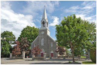
Church of Saint - Francois-de-Sales


The Church of Saint-François-de-Sales, built in 1854, presents twenty-six paintings by artiste Antoine Plamondon (1804-1895), who also served as mayor of the village.

The Seigneurial Manor of Larue, built in 1835 on a small rolling hill, is one of the major buildings that make up Neuville’s architectural heritage. The Rue du Quai leads to the quay and the marina, which welcomes boating enthusiasts each summer.


Castel Vauquelin Hotel - Neuville, QC


Neuville, QC is 210 km (2 hrs.) from St. Hyacinthe and 34 km (35 min.) from Quebec City.

Friday, April 15, 2016

M is for Mount Royal

Tobogganing on Mount Royal in the 1940's was a highlight for my uncles and mother, they would sled until exhaustion and walk home to hot chocolate and a cozy fire.


Mount Royal (French: mont Royal) is a large hill or small mountain in the city of Montreal, immediately west of downtown Montreal, Quebec (in Canada), the city to which it gave its name.

The hill is part of the Monteregian Hills situated between the Laurentians and the Appalachian Mountains. It gave its Latin name, Mons Regius, to the Monteregian chain.
The hill consists of three peaks: Colline de la Croix (or Mont Royal proper) at 233 m (764 ft), Colline d'Outremont (or Mount Murray, in the borough of Outremont) at 211 m (692 ft), and Westmount Summit at 201 m (659 ft) elevation above mean sea level.

History of Mount Royal

The Cross on Mount Royal


Mount Royal Funicular Railway - 1900


There are two cemeteries in the area: Notre Dame des Neiges Cemetery (Catholic) and Mount Royal Cemetery (non-denominational but primarily Protestant, and including several small Jewish cemeteries) — both of which are now running out of space. In 2008, the refusal of the Notre Dame des Neiges Cemetery to cede land that it uses as a depot blocked a planned expansion of the park


Outside the park, Mount Royal's slopes are also home to such Montreal landmarks as St. Joseph's Oratory, Canada's largest church; McGill University and its teaching hospitals, including the Royal Victoria Hospital and Montreal General Hospital; McGill's Molson Stadium, home to the CFL's Montreal Alouettes; the McTavish reservoir; Université de Montréal; the École Polytechnique de Montréal; the Îlot-Trafalgar-Gleneagles historic block; and some well-off residential neighbourhoods such as Upper Westmount and Upper Outremont.

Mount Royal is 59 km (56 min.) from St. Hyacinthe and 254 km (2 hrs. 48 min.) from Quebec City.

Thursday, April 14, 2016

L is for Laval

Laval and the surrounding area hold a special place for me as that is where my absolutely favorite aunt and uncle lived most of their married lives. I had the opportunity to visit several times and never felt more at home than when I was with Aunt Lili and Uncle Lorne. Wonderful bittersweet memories as both my uncles, Lorne and George have passed on and are buried at Sainte - Dorothee.


The first European Settlers were Jesuits in 1636 when they were granted a seigneury there. Agriculture first appeared in Laval in 1670. In 1675, François de Montmorency-Laval gained control of the seigneury. In 1702 a parish municipality was founded, and dedicated to Saint-François de Sales (not to be confused with the modern-day Saint-François-de-Sales in Saguenay–Lac-Saint-Jean).

The first municipalities on the island were created in 1845, after nearly 200 years of a rural nature. The only built-up area on the island, Sainte-Rose, was incorporated as a village in 1850, and remained as the main community for the remainder of the century. With the dawn of the 20th century came urbanization. Laval-des-Rapides became Laval's first city in 1912, followed by L'Abord-à-Plouffe being granted village status three years later.

Laval-sur-le-Lac was founded in the same year on its tourist-based economy from Montrealers. Laval began to grow throughout the following years, due to its proximity to Montreal that made it an ideal suburb.

To deal with problems caused by urbanization, amalgamations occurred; L'Abord-à-Plouffe amalgamated with Renaud and Saint-Martin creating the city of Chomedey in 1961. The amalgamation turned out to be so successful for the municipalities involved that the Quebec government decided to amalgamate the whole island into a single city of Laval in 1965; however the passage of amalgamation bill was not without controversy.

Laval was named after the first owner of Île Jésus, François de Montmorency-Laval, the first Roman Catholic Bishop of Quebec. At the time, Laval had a population of 170,000. Laval became a Regional County Municipality in 1980. Prior to that, it was the County of Laval.
The 14 municipalities, which existed prior to the incorporation of the amalgamated City of Laval on 6 August 1965, were:

  • Auteuil
  • Chomedey
  • Duvernay
  • Fabreville
  • Îles-Laval
  • Laval-des-Rapides
  • Laval-Ouest
  • Laval-sur-le-Lac
  • Pont-Viau
  • Sainte-Dorothée
  • Sainte-Rose
  • Saint-François
  • Saint-Vincent-de-Paul
  • Vimont

Laval is 68 km (51 min.) from St. Hyacinthe and 267 km (2 hrs. 45 min.) from Quebec City.


Wednesday, April 13, 2016

K is for Kirkland

The city of Kirkland is named after Charles-Aimé Kirkland, a Quebec provincial politician. It was originally incorporated as a municipality in 1961. On January 1, 2002, as part of the 2002–2006 municipal reorganization of Montreal, it was merged into the city of Montreal and became a borough.

Note: Kirkland de-merged several years ago and is no longer part of Montreal. It is its own city, with its own mayor and city council.

Several notable athletes called Kirkland home:

Tanith Belbin - Ice Dancer
Louis Leblanc - Hockey Player
Randy McKay - Hockey Player
Brandon Reid - Hockey Player
Sergio Momesso - Hockey Player

Celebrate Kirkland Day!


Kirkland, QC is 82 km ( 1 hr. 11 min.) from St. Hyacinthe, QC and 277 km (3 hrs.) from Quebec City, QC